Have you ever heard the cliché you are missing the forest for the trees? Or is it the other way around? The tree for the forest? In either case, this cliché could apply to earth and the flood geology evidence that surrounds us on earth. There is plenty of evidence to support this devastating event, found on every continent on a massive scale. The floodwaters would have covered even the highest mountain peaks.
Was the global flood of the Bible a mere analogy or perhaps simply a mythology handed down over generations? Or, could it have happened? Unfortunately, either way, the evidence we observe today does not provide definitive answers. Why? Because no one can travel back in time to observe the past. All we can do today is examine the evidence and determine if a global flood likely happened or find that evidence is lacking.
Uniformitarianism vs. Catastrophism
A common saying among geologists is ‘the present is the key to the past.’ Meaning what we observe today is likely the way it has always been for all time. It is essentially slow and gradual (with a catastrophe like an earthquake or a tsunami here or there) but, overall, slow and steady natural processes. This is called a uniformitarian view. Uniformitarian views apply today to most all geologic, fossil, and radiometric data.
By contrast, catastrophism is a doctrine that sees present-day rates as vastly insufficient supporting evidence for the geologic, fossil, or radiometric data. This view finds present-day processes occurring at significantly slower rates than those observed during past catastrophic events of the past.
An excellent example that stands in contrast to uniformitarianism is observing and measuring the erosion rate at Niagara Falls and Mount Saint Helen’s.
Data shows that uniformitarian views do not support Niagara Falls because it erodes at about one foot per year. This rapid erosion rate proposes a puzzle from the uniformitarian perspective because The Falls are too young to have continuously eroded at this observed rate since the Ice Age. Additionally, current natural processes do not answer how all the water pounding through The Falls came into being. Current precipitation rates and river accumulations do not account for all this freshwater. Rains or rivers do not replenish this massive body of water that makes up the Great Lakes, and the Falls freshwater is a runoff on an enormous scale.
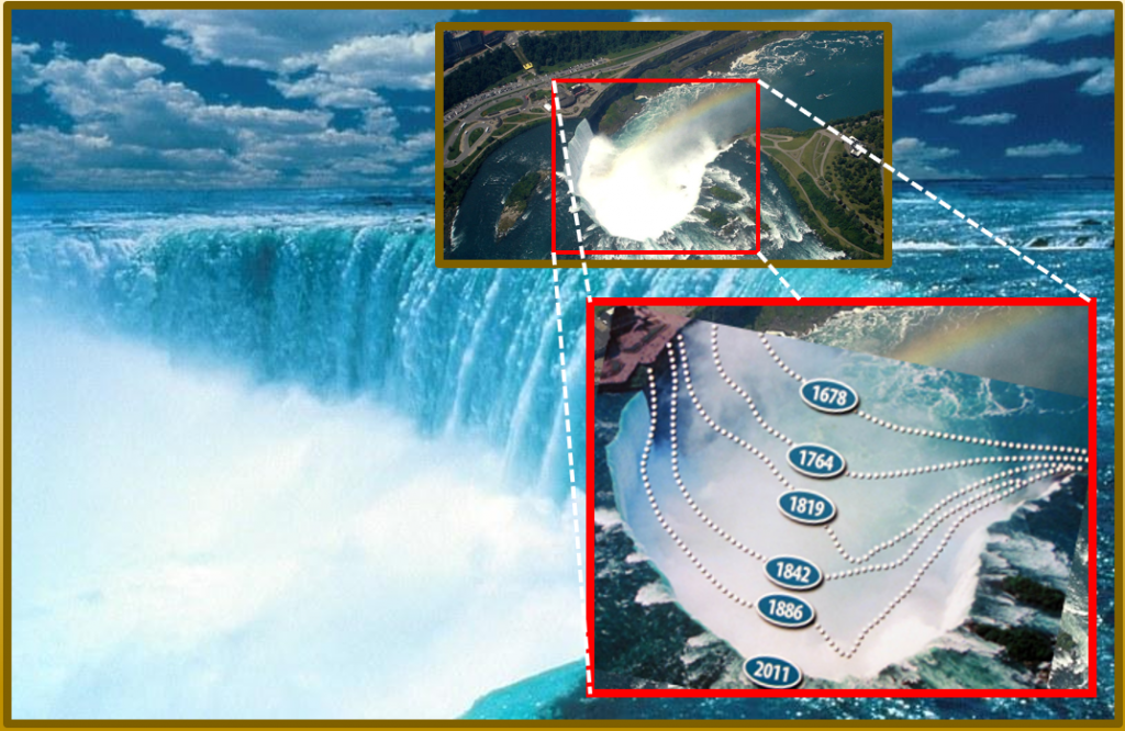
From the catastrophic perspective, many elements of Niagara Falls suggest a past catastrophe. The destructive view would expect to find erosion rates as observed today. There is so much water crushing through Horseshoe Falls that it is estimated that the total water still held within the Lakes would cover the entire continent of North American by more than three feet deep.
However, this water is not being replenished- why is it there? Where did it come from? It is thought that the great lakes are remnants of the ice age. Scientists further speculate that the Falls will be completely dry at current runoff rates in only about 2,000 years.
Mount Saint Helens
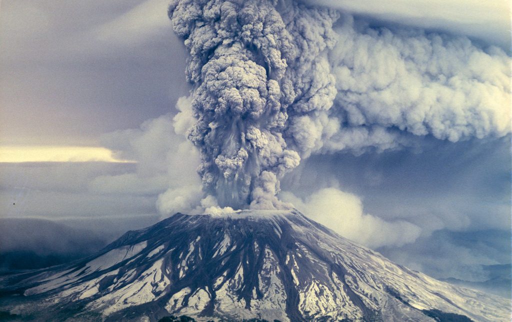
Mount Saint Helen’s erupted in a massive volcanic explosion at 8:32 AM Sunday on May 18, 1980. Thereby effectively becoming an active laboratory for observable catastrophism. This event transformed many scientists’ uniformitarian views as they witnessed and recorded (on video) badlands of solid rock eroding over mere days. Rapid erosion carved massive canyons hundreds of feet deep in a single day, while sedimentary layers were laid over twelve five feet thick in an afternoon. Over two years, this erosion cut solid rock and formed a new canyon dubbed “The Little Grand Canyon,” although much smaller than The Grand Canyon, its similarity from an Arial view was striking.
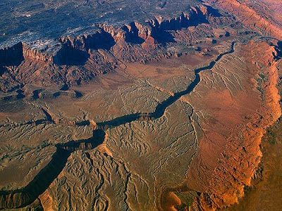
“Little Grand Canyon” of Mount Saint Helens
Three separate eruptions produced sedimentary layers hundreds of feet thick. One of these eruptions was at hurricane velocity; it produced thousands of thin lamination up to twenty-five feet thick—all with highly refined layers. The third and final eruption of this catastrophe involved a lava flow. This flow became a hot mudflow that pressed crossed the Toutle River. This hot mudflow etched through the river and carved out seventeen miles of canyons as deep as one hundred and forty feet. This lava flow completed this in a matter of hours. Today this seventeen-mile canyon is called the “Little Grand Canyon of the Toutle River,” strikingly similar to the Grand Canyon.
The catastrophe of Mount Saint Helens shows us what havoc a regional disaster can render in a brief time period. If a geologist were honest, they would admit that they would assume the canyons were over millions of years, not hours, without witnessing the eruption of Mount Saint Helens. Mount Saint Helens stands as a powerful testament to the power of even a local catastrophe on geologic landscapes.
Global Flood Evidence?
If there was a global flood, what evidence would we expect to find? We would expect to see the erosion of solid rock and soils over vast continents. We would discover sedimentary pulverized fragments of rock and oceanic materials spread over enormous areas and re-deposited. We would expect to find vast sedimentary runoffs from when the waters receded, reforming the dry land. We would see massive re-depositing of materials spanning great distances away, laying sediment, bending vast layers as laid down while still wet, leaving huge layers without any evidence of plant, insect, or living things. There would be layers as massive burial grounds rich in dead plants and animal fossils. We would see these fossils and remains even on the highest mountain peaks. This evidence is exactly what we find on earth today.
Fossils

Fossils can be formed in a multitude of ways. Specimens can be frozen, dried, asphalted, amber, or carbon distillation. Some fossils are only imprints, while others are the actual remains. The fact is there are billions of fossils, and nearly all of them are oceanic. Of all fossils, 95% are marine, 4.75% are algae and plants, .25% are invertebrates, .0125% are fish, the balance is vertebrates, including dinosaurs fossils where 95% of those specimens have less than one bone. 95% of all mammal fossils come from the ice age or post-flood era. Many dinosaur exhibits are 99% replication and assumption and less than 1% actual evidence. These are all created by water caught in sedimentary layers and then later dried as the waters receded. Despite all these fossils, fossilization is not shared. It never occurs under normal decay processes. The evidence of fossils alone indicated mass sedimentation being laid down by even more massive bodies of water. If these fossils were created in a global flood event, we would expect to find them, and again this is exactly what we do find.
Fossils on highest mountain tops
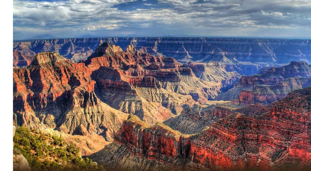
Additionally, geological strata contain marine fossils as critical evidence that the ocean once covered the continents, even the highest continental areas. Extremely widespread strata blankets argue for an intercontinental or global flood. For example, most of the rock layers in the Grand Canyon walls (more than a mile above sea level) contain marine fossils, and fossilized shellfish are even found in the Himalayas. If we had a global flood, we would expect to find fossils even on the tops of the highest mountains, and again, this is what we find.
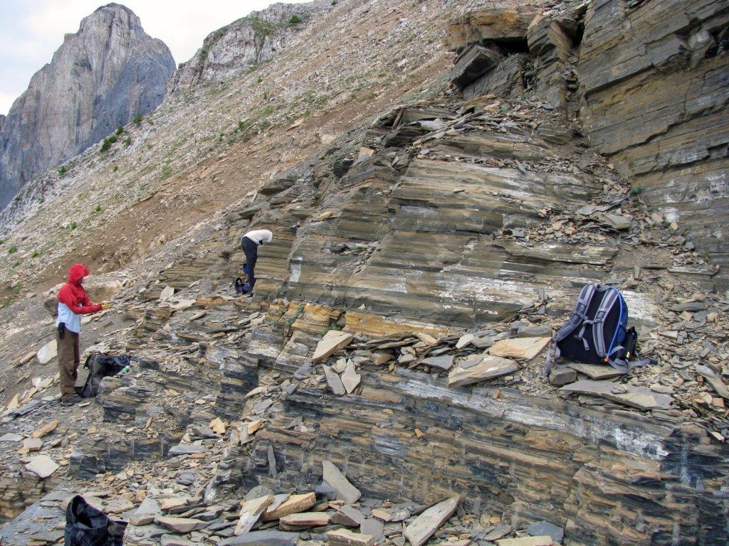
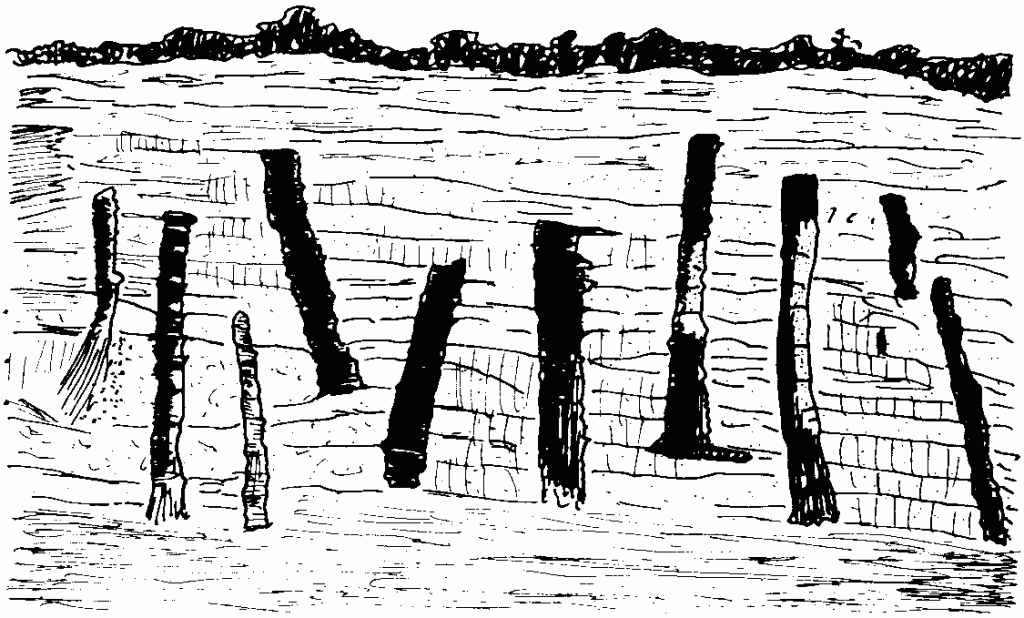
Polystrate Fossils
A polystrate fossil is a tree standing straight up through the rock layers of sediment, which the evolutionists thought to represent millions of years of layers. Some polystrate tree fossils could not have grown where the surrounding shale was deposited since trees don’t live long under the sea.
This burial is supposed to have been completed very slowly, over millions of years. During this time, billions of tiny shale-sized particles are deposited layer slowly by layer. Then heat and pressure covered these fossil trees.
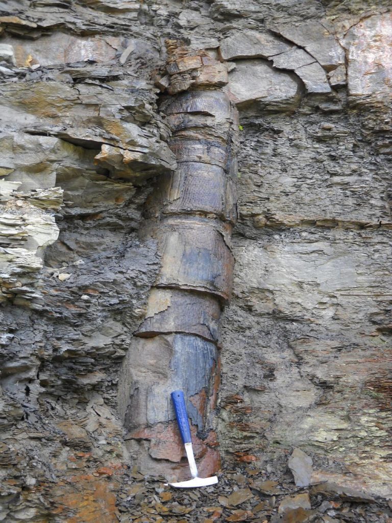
Using uniformitarian principles, the time required for shale sediments to accumulate summed to many thousands of years. The evidence indicates that the shale was deposited quickly over the trees, still standing upright during a catastrophe. Many of these trees were buried at the same time when all the rock layers were yet still liquid. Polystrate fossils are found all around the world and are yet additional evidence for a global flood.
Coal Beds & Rapid Burial of plants and animals
We find extensive fossil “graveyards,” of which some are exquisitely preserved. For example, billions of nautili fossils are found in a layer within the Redwall Limestone of the Grand Canyon. The chalk and coal beds of Europe and the United States, fish, ichthyosaurs, insects, and other fossils worldwide testify of catastrophic destruction and burial.
Fossil Forests
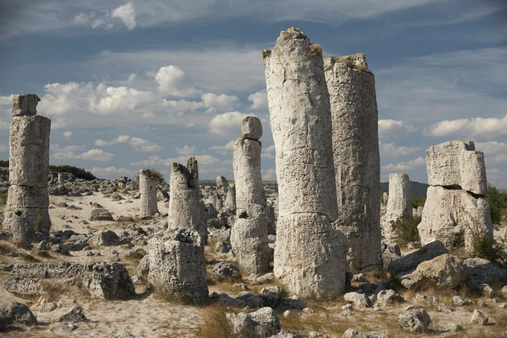
The world has many petrified forests found on nearly every continent on earth. The Petrified Forest is known for its fossils, significantly fallen trees that lived in the Late Triassic Period, supposedly about 225 million years ago. The sediments containing the fossil logs are part of the widespread and colorful formation from where the Painted Desert of Arizona got its name. If the petrification of wood operates independent of other forms of fossilization, why are the two found together? The evidence indicates it could be because they were both laid down rapidly by water simultaneously.
Sedimentary Rock layers
Tapeats Sandstone spans North America and most other continents on earth. Granular, water-charged sediment flows result in very rapid stratification. We find rock layers that can be traced across continents—even between continents—and physical features in those strata indicate they were deposited rapidly. Concentrated sediment flows produce thick strata sequences by abrupt deposition from liquefied suspension or evenly bedded strata by flow transformation to a tractive current.
Erosion or no erosion
We find evidence of rapid erosion, or even of no erosion, between rock layers. Flat, knife-edge boundaries between rock layers indicate continuous deposition of one layer after another, with no time for erosion.
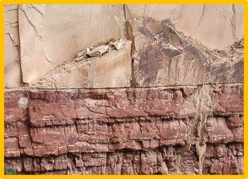
There is no evidence of any “missing” millions of years (of erosion) in the flat boundary between two well-known layers of the Grand Canyon—the Coconino Sandstone and the Hermit Formation. Another impressive example of flat boundaries at the Grand Canyon is the Redwall Limestone and its strata.
Sediments transported great distances.
We find that the sediments in those widespread rapidly deposited rock layers had to be eroded from distant sources and carried long distances by fast-moving water. For example, the Coconino Sandstone of Grand Canyon (Arizona) had to be eroded and transported from the northern portion of what is now the United States and Canada. Furthermore, current water indicators (such as ripple marks) preserved in rock layers show that for “300 million years,” water currents were consistently flowing from northeast to southwest across all of North and South America. Such results are plausible to be caused by the Global Flood.
Sorting of layers
Experiments from Colorado State University utilized modern technology. Scientists took place in large glass-walled flumes, which allowed observation and filming from above and through the tanks’ sides. Different-sized particles of sand were poured into water circulating in the flume, and variations in current velocity caused the particles to be sorted according to size. The sediment accumulation produced a deposit consisting of the downstream part of the lower laminae, part of the sloping stratum of larger particles, and the upstream region of the upper laminae. Each deposit formed successively downstream and was, therefore, younger than the one before it. Variations in current velocity, as found in rivers and oceans, could thus cause deposits to form both vertically and laterally at the same time in the direction of the current.
This and other experiments have demonstrated the mechanical nature of stratification, whereby: (a) Particles segregated according to their size when transported by a current of variable velocity by water or some other force; (b) Desiccation, or drying out, of deposits caused bedding partings; (c) Stratification of the deposit, under both dry and wet conditions, formed parallel to the slope of the deposit. (1)
These laboratory experiments have shown that automatic sorting and layering occur with sand, mud, and clay slurry sorted by size. The sand, dirt, and clay will spontaneously precipitate (or settle out) and form individual layers when the mixture slows down. This event was witnessed at the Mount Saint Helens eruption as mudflows laid down massive layers over a few afternoons.
Many strata laid in rapid succession: Bent Rock layers
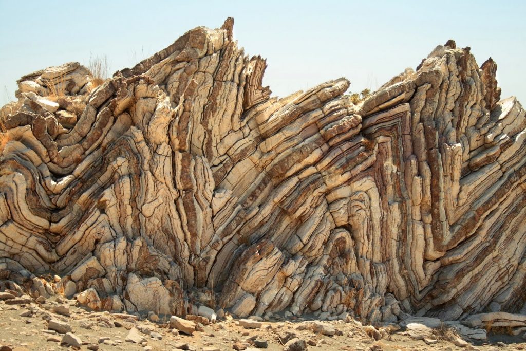
In many mountainous areas, rock layers thousands of feet thick have been bent and folded without fracturing. How can that happen if they were laid down separately over hundreds of millions of years and already hardened? Hello? Rocks do not normally bend; they break because they are hard and brittle.
However, in many places worldwide, we find entire sequences of solid rock strata bent without fracturing. This evidence indicates that all the rock layers were rapidly deposited and folded while still wet and pliable before final hardening. For example, the Tapeats Sandstone in Grand Canyon is folded at a right angle (90°) without breaking. Yet this folding could only have occurred after the rest of the layers had been deposited, supposedly over “480 million years,” while the Tapeats Sandstone remained wet and pliable. The region around Grand Canyon is a great example showing how most of the earth’s fossil-bearing layers were laid down quickly, and many were folded while still wet.
Conclusion
The evidence that a global flood has occurred in the past is overwhelming. Every area of evidence supports the possibility of a worldwide flood, as described in the Bible. Examples of evidence were created by massive floodwaters, which were fossils, polystrate trees, bent rock layers, coal formation, and many others. Again, we cannot go back and confirm the Bible’s account or its timing, but neither can naturalism. However, we can certainly review the data and conclude that the plausibility of a global flood abounds.
Resources
http://www.icr.org/article/experiments-stratification/
Dr. Duane Gish stated 270 flood stories in their writings in 1992. Since this time, Laura Welch & Bodie Hodge have concurred on nearly 500 flood accounts.
Duane Gish, Dinosaurs by Design p.74; Bodie Hodge & Ken Ham, A Flood of Evidence p.33
Main Image Credits: Copyright Puwadol Jaturawutthichai | Dreamstime.com
https://www.dreamstime.com/stockdevil_info